 A cutting-edge project in the New Forest is succeeding in its quest to record and protect thousands of archaeological sites for the future.
Previous finds include prehistoric field systems, an Iron Age hill fort and World War II bomb test sites. This year has seen another 433 sites and features identified, including some of the best preserved Bronze Age barrows in the New Forest.
The heritage mapping project uses many different sources of information to identify, record and manage archaeological features found on the open Crown lands of the National Park.
The project is funded by the New Forest Higher Level Stewardship (HLS) Scheme, a 10-year agreement with Natural England worth £19m. The scheme is held by the Verderers of the New Forest and managed by them in partnership with the Forestry Commission and the New Forest National Park Authority.
Many of the historical sites discovered so far were hidden under dense forest and thick heather until HLS archaeologists used a plane to fire harmless laser beams onto the ground to build a 3D map of its surface. The Light Detection and Ranging technology (Lidar) can penetrate the tree canopy, revealing features which cannot be seen by other means.
In order to get a fuller picture of how archaeological sites have been used over the years, Lidar must be combined with more traditional survey techniques. This includes aerial photography, infra-red images and field work to check features on the ground.
Heritage mapping highlights from the last year include:
- More than 2,000 hectares (2,800 football pitches) surveyed by archaeologists and volunteers in the last year
- Over 400 sites catalogued and recorded to protect them in the future
- Volunteers contributed more than 320 hours to the project
- A public exhibition on heritage mapping in the New Forest attracted nearly 20,000 people
- Archaeological guidance provided on 14 wetland restoration consultations, resulting in 208 sites being recorded.
Official Verderer Dominic May, said: ‘This has been a successful year for this project and builds on what has already been achieved since 2011. Combined with previous years’ work, we have now completed 12,000 hectares of LiDAR analysis, which is over 60 per cent of the HLS area, and we are on target to complete the analysis by 2020.
‘Over the last year volunteers have proven invaluable in this project, helping with tasks ranging from survey work to data cleaning and heritage events where they have represented the projects work. Lawrence Shaw at the National Park Authority is running this project, and, together with these volunteers, they are making a lasting difference to the New Forest.’
Lawrence Shaw, Heritage Mapping and Data Officer for the New Forest National Park Authority, said: ‘The creation of the New Forest in 1079 produced a unique situation where archaeological sites have been almost frozen in time, mostly free from pressures such as intensive modern farming techniques and urban development.
‘As a result we have been able to find fantastically well preserved sites that have been undisturbed for hundreds of years. The Lidar data gives us an opportunity to peel back the layers of the New Forest’s history and see how it has been shaped by human activity from the Bronze Age all the way through to World War II. The last year’s work has seen our understanding continue to grow and has made a real difference to how we manage these important sites and features in the future.’
Through the HLS Scheme and other projects, the New Forest has become the first National Park in the country to have its entire landscape surveyed by Lidar. The survey also mapped surrounding communities – an area the size of 92,000 hectares or 350 square miles.
The public can see the results for themselves online, zooming in to interesting locations at www.newforestnpa.gov.uk/heritagemapping.
-ends-
Notes to photo editor
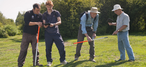
Lawrence Shaw, Heritage Mapping and Data Officer, surveying in the New Forest with volunteers.
Notes to Editors
1. The role of the Verderers of the New Forest is to protect and administer the New Forest’s unique agricultural commoning practices; to conserve its traditional landscape, wildlife and aesthetic character, including its flora and fauna, peacefulness, natural beauty and cultural heritage; and to safeguard a viable future for commoning. www.verderers.org.uk
2. The Forestry Commission is the government department responsible for forestry in Great Britain. It supports woodland owners with grants; tree felling licences, regulation and advice; promotes the benefits of forests and forestry; and advises Government on forestry policy. It manages more than a million hectares (2.5 million acres) of national forest land for public benefits such as sustainable timber production, public recreation, nature conservation, and rural and community development. For more information, visit www.forestry.gov.uk/newforest
3. Natural England is the government’s advisor on the natural environment. Established in 2006 our work is focused on enhancing England’s wildlife and landscapes and maximising the benefits they bring to the public. www.gov.uk/natural-england
4. The Environmental Stewardship Scheme, of which HLS is one strand, is administered by Natural England, on behalf of Defra, and funds farmers and land managers throughout England to deliver effective environmental management on their land.
The objectives of Environmental Stewardship are to:
- Maintain and enhance landscape quality and character
- Protect the historic environment and natural resources
- Conserve biodiversity.
- Promote public access and understanding of the countryside
The ES scheme is now closed to new applicants and has now been succeeded by the Countryside Stewardship scheme.
5. The New Forest National Park Authority works with partners to conserve and enhance the natural beauty, wildlife and cultural heritage of the National Park and to promote opportunities for understanding and enjoyment of its special qualities. It also has a duty to foster the social and economic well-being of local communities within the Park. www.newforestnpa.gov.uk
Media Contact
Matt Stroud
Engagement and Interpretation Officer, New Forest HLS Scheme
Matt.stroud@newforesthls.org
01590 646650